Having to abandon ship or call for emergency assistance is every sailor’s nightmare when making a crossing. It’s the moment when you become dependent on others for your safety and survival. What emergency alert systems are available on the market?
.png)
Calling for help or needing rescue is something no one wishes for. Yet, such situations can arise without warning.
A dismasting in heavy weather, a collision with a floating object, a serious injury, or a fire outbreak... all are scenarios where the risk is very real.
Fortunately, there is now a wide range of equipment designed to send alerts and request assistance. Let’s take a closer look to get a clearer picture!
The well-known VHF radio transmits signals in a straight line, which explains its relatively limited range. A handheld VHF will not transmit beyond 5 to 6 nautical miles.
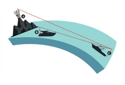
Fixed VHF radios with an antenna mounted at the top of the mast offer a much greater range, reaching up to 25 nautical miles.
Antenna height plays a key role in signal range, as does the type of VHF used. Handheld models, powered by batteries, are limited to an output of 5 to 6 watts.
In contrast, fixed VHF radios, powered by the boat’s electrical system, can transmit at up to 25 watts.
A handheld VHF is therefore mainly intended for short-range communication—such as harbor maneuvers or emergencies—kept in a grab bag, for example.
It does not replace a fixed VHF for long-distance communication.
DSC, or Digital Selective Calling, allows you to use your VHF radio to communicate directly with a specific recipient.
In an emergency, sending a DSC distress message automatically alerts a nearby coastal rescue center. This message includes the nature of the incident and the vessel’s identification via its MMSI number (a unique maritime identifier).
This signal is typically sent by holding down the “Distress” button on the VHF radio.
Once the distress signal has been transmitted, it is essential to switch to channel 16 to continue communication with rescue services.
DSC also enables you to contact another VHF radio directly—within range—provided you know its MMSI number.
Unlike distress beacons, phone networks—whether terrestrial or satellite-based—are not part of a structured rescue system. They allow communication, but do not automatically trigger a rescue response.
Mobile phones (2G, 3G, 4G, 5G) rely on a network of land-based antennas that relay incoming and outgoing signals. Their range is typically limited to about 5 nautical miles, but can reach up to 15 NM in optimal conditions using a directional antenna or a GSM booster.
The actual range depends on several factors: air humidity, weather conditions, and most importantly, the height of the device above sea level.
For all these reasons, GSM is not considered a reliable means of triggering rescue at sea.
Note: Some recent iPhone models are now equipped with Starlink connectivity (still in beta), which could expand communication possibilities in the future.
Networks such as Iridium, Globalstar, or Starlink use constellations of satellites to enable communication from almost anywhere in the world.
“Almost” because coverage gaps still exist, depending on the network and its satellite footprint.
The key feature of these systems is that they do not rely on any ground-based antennas: communication is established directly between the device and the satellites, independently.
Satellite phones therefore allow you to call or send a message to a rescue center—even on the open sea—provided you are using a compatible device.
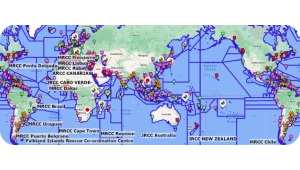
Maritime rescue centers, known as MRCCs (Maritime Rescue Coordination Centres) or JRCCs (Joint Rescue Coordination Centres), are located around the world to coordinate maritime search and rescue operations.

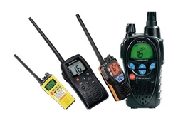
The Iridium satellite network offers global coverage. To access it, you need a dedicated device, a modem, or an accessory that can be connected to a smartphone.
These devices require a voice and/or data subscription, which can be quite expensive. One of their main advantages is their compact size—similar to that of a smartphone—allowing them to fit in a pocket and operate without the need for an external antenna.
These other networks, with characteristics similar to Iridium but more limited coverage areas, also operate with dedicated handheld devices. They require a subscription or data packages.
In general, satellite phones from Iridium, Globalstar, Thuraya, or Inmarsat are robust, smartphone-like devices that work without an external antenna and have their own built-in battery. They can easily be stored in a grab bag.
Recently—and in limited regions—some iPhones have gained the ability to send a message via the Globalstar network without any additional hardware. Apple has acquired a 20% stake in the satellite operator. Could this be the future of Apple’s satellite communication?
It’s worth noting that Globalstar, Thuraya, and Inmarsat are not high-bandwidth networks.

The newcomer in satellite communications is based on a constellation of low-Earth orbit satellites—small, low-cost units.
Starlink systems require an external antenna, but offer very high upload and download speeds, making them suitable for video transmission. Starlink is a fixed modem that needs a power supply and the outdoor installation of an antenna. It is not a portable device.
Starlink, Apple, and the Opening of Smartphones to Satellite Communication
Apple and Starlink have announced the launch of a feature allowing smartphones to connect to Starlink satellites in emergency situations. This requires using Apple software that helps the device align with a satellite.
Currently, this feature is being tested in the U.S. with T-Mobile and only allows SMS messaging.
It is highly likely that the next generation of smartphones will be compatible with this network.
Beacons are alerting devices, not communication tools like those previously mentioned. A beacon is used only in emergency situations.
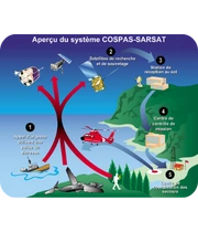
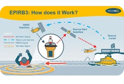
The Cospas-Sarsat network is a global distress alert and location system.
At sea, distress signals are transmitted by beacons—EPIRBs, which are registered to the vessel, or PLBs, which are personal devices—that operate on the 406 MHz frequency.
This system relies on third-party satellites that pick up the signals and relay them to ground stations. The data is then forwarded to control centers, which notify the appropriate rescue services to coordinate search and rescue operations.
The system offers a location accuracy of about 1 nautical mile. Modern models equipped with GPS can reduce that margin to just a few hundred meters.
Position transmission is instantaneous and continuously updated.
The routing of distress signals to the relevant rescue centers is fully managed by the system.
This automatic routing is what makes COSPAS-SARSAT stand out compared to the previously mentioned communication tools.
In France, Division 240 requires that an EPIRB (Emergency Position Indicating Radio Beacon) be carried on board for any offshore navigation. In French, this device is known as a Radiobalise de Localisation des Sinistres.
Offshore navigation is officially defined as sailing beyond 60 nautical miles from a safe haven.
The beacon must be programmed with the vessel’s MMSI number and registered with the ANFR (Agence Nationale des Fréquences, or National Frequencies Agency).

These beacons are encoded with information related to the boat. When activated, they transmit this data—along with the vessel’s position—directly to a rescue coordination center (MRCC) via the global maritime distress and safety system (GMDSS), anywhere in the world.
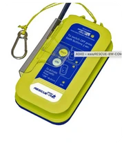
EPIRBs are equipped with a battery and an antenna, and are considered part of the boat’s mandatory safety equipment. When needed, they are portable and intended to be taken aboard the life raft.
An example: the Ocean Signal EPIRB3 Pro—a compact model with AIS functionality, return link service, and a strobe light.
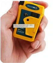
These other beacons are also recognized by the GMDSS (Global Maritime Distress and Safety System), but they are personal, hence their name: Personal Locator Beacon (PLB).
A PLB—such as the PLB1 from Ocean Signal—can be used not only at sea but also in the mountains, forests, or other remote areas.
However, owning a PLB at sea does not exempt you from carrying an EPIRB.
But why can't a PLB serve as a replacement for an EPIRB?
These personal beacons are less powerful and have shorter antennas, which allows them to transmit a distress signal at sea, but less reliably than an EPIRB.
They also generally have a shorter transmission autonomy, compared to an EPIRB which typically exceeds 48 hours.
PLBs do not comply with the requirements of Division 240.
These devices—such as the Easy Rescue AIS from Weatherdock—emit a signal intended for the AIS receivers of nearby vessels. Their effectiveness depends on two main factors:
AIS beacons are sometimes integrated into an EPIRB or a PLB, providing an excellent complement. The satellite alert reaches the MRCC, while the AIS signal guides nearby vessels directly to the survivors.
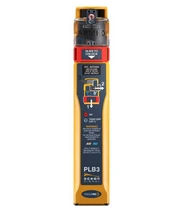
This is the case, for example, with the Ocean Signal PLB3, a device that can even indicate whether the distress signal has been received or not!
In response to the increasing number of drownings along the coast, the SNSM (French Sea Rescue Organization) has developed an individual GSM beacon combined with a satellite receiver.
These personal beacons, worn as a wristband, allow the wearer to alert a trusted contact, who can then notify the rescue services.
They operate via the GSM network, which means their range is limited (typically 5–6 nautical miles). No mobile coverage, no signal.
These devices do not comply with the requirements of Division 240 and are not considered official distress beacons.
